NISAR radar catches a Kamchatka volcano erupting
NASA's NISAR satellite has stitched 17 radar frames of Krasheninnikov, quiet since about 1550, into a time-lapse of lava filling and spilling from its craters.
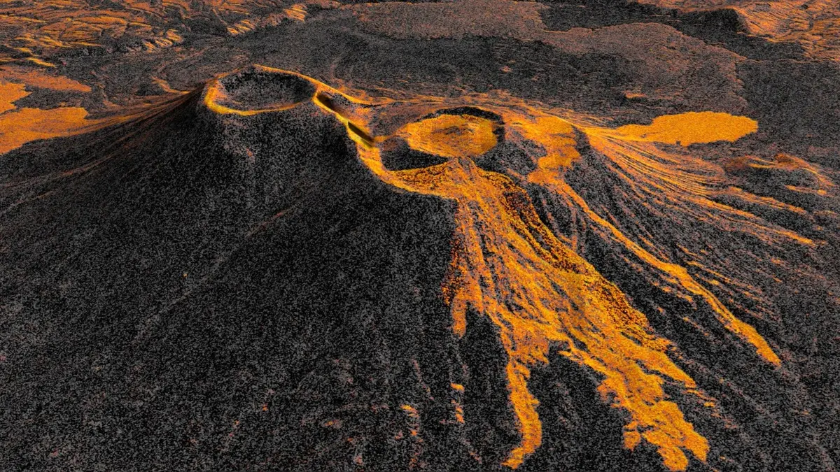
NASA's NISAR satellite has been watching a volcano that had kept quiet for close to five centuries, and the agency has now turned those observations into a time-lapse. The joint NASA-ISRO radar mission imaged Krasheninnikov, a twin-cratered volcano on Russia's Kamchatka Peninsula, from 464 miles (747 kilometres) above the surface, beginning on 25 December 2025 as the satellite finished its post-launch checks and became operational.
What the radar is showing
Twice every 12 days since then, NISAR has looked at the same patch of ground. Researchers put 17 of the frames captured through mid-August into sequence, producing footage in which lava fills a smaller inner caldera, overflows into a wider crater and then spreads into a fan. That Krasheninnikov had not erupted since about 1550 is what makes the record unusual: this is a volcano with almost no recent history to compare it against.
The sharpness comes from synthetic aperture radar, a processing technique pioneered by NASA's Jet Propulsion Laboratory for Earth observation. Each pixel in the individual frames represents roughly a 30-foot-by-30-foot (10-metre-by-10-metre) patch of ground. Lava reads brighter than the terrain around it because microwaves reflect off it differently than they do off snow or bare rock.
Matthew Pritchard, a member of the NISAR science team and a geophysicist, pointed to the cadence rather than the single image. “The consistency is crucial,” he said. “Twice every 12 days, acquiring in this high-resolution mode and in two observation directions, this shows the promise of NISAR to closely monitor natural hazards.”
Why you should care
NISAR is the first free-flying space mission to carry two radar instruments, an L-band system and an S-band system. The longer L-band waves can pass through tree canopies, which is why the same satellite is being used on forests and ice as well as on volcanoes. Its L-band data products are distributed through the Alaska Satellite Facility Distributed Active Archive Center in Fairbanks.
Pritchard said the change since his own doctoral work on Kamchatka more than 20 years ago is stark. Analysis-ready radar data was hard to come by then, because satellites revisited less often and the images were coarser. “We're seeing volcanoes around the world that we've never really had eyes on like this before,” he said. The mission now reaches virtually all of the planet's roughly 1,300 active volcanoes that sit above sea level.
Our opinion
A time-lapse of one volcano is a pleasing video, but the actual product here is a schedule. Volcano monitoring has always been a trade between how often you look and how much you can carry, and radar is the only instrument that ignores cloud, darkness and the ash plume itself. The reason Krasheninnikov matters is that nobody was watching it closely, and the satellite covered it anyway. That is the difference between targeted monitoring and a baseline. Aviation authorities, insurers and civil-defence planners do not act on a dramatic photograph; they act when a reading arrives on time, repeatedly, from a place they had not thought to instrument. NISAR's real achievement in Kamchatka is not that it caught the eruption, but that the eruption did not have to be noticed first for it to be recorded.